|
|
|
|
|
|||||||||||||||||||||||||||||||||||||||||||||
|
|
|
|
|
|||||||||||||||||||||||||||||||||||||||||||||
|
The only sub-meter ruggedized
hand-held GPS/GIS receiver on the market An excellent unit for precision
agriculture, hydrographic surveys, and utility mapping. Signal inaccuracies are removed
with RAIM (Receiver Autonomous Integrity Monitor). The built-in strobe
correlator technology provides unmatched multi-path mitigation for code. A proven and reliable GPS
unit for GIS applications.
|
|
|||||||||||||||||||||||||||||||||||||||||||||||
|
|
|
|||||||||||||||||||||||||||||||||||||||||||||||
|
|
|
|
|
|
|
|||||||||||||||||||||||||||||||||||||||||||
|
|
|
|
|
|
||||||||||||||||||||||||||||||||||||||||||||
|
|
|
|
|
|
||||||||||||||||||||||||||||||||||||||||||||
|
|
List Price: |
$3,850.00 |
$4,550.00 |
|
||||||||||||||||||||||||||||||||||||||||||||
|
|
GPS receiver: |
12 channel |
12 channel |
|
||||||||||||||||||||||||||||||||||||||||||||
|
|
DGPS Beacon Receiver: |
No |
Yes |
|
||||||||||||||||||||||||||||||||||||||||||||
|
|
Professional GPS/GIS: |
Yes |
Yes |
|
||||||||||||||||||||||||||||||||||||||||||||
|
|
Mapping Accuracy: |
C/A Code: 50 -
90 cm |
|
|||||||||||||||||||||||||||||||||||||||||||||
|
|
Designed for easy use: |
Yes, CMT Field 3.8 Included |
|
|||||||||||||||||||||||||||||||||||||||||||||
|
|
On-board Traverse: |
Yes |
Yes |
|
||||||||||||||||||||||||||||||||||||||||||||
|
|
Post Processing: |
Yes |
Yes |
|
||||||||||||||||||||||||||||||||||||||||||||
|
|
Memory: |
4 MB standard |
4 MB standard |
|
||||||||||||||||||||||||||||||||||||||||||||
|
|
Records Points, |
Yes |
Yes |
|
||||||||||||||||||||||||||||||||||||||||||||
|
|
GPS/GIS Mapping Software: |
Yes, PC-GPS 05 Included |
|
|||||||||||||||||||||||||||||||||||||||||||||
|
|
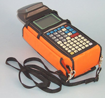
Waterproof: |
Yes, submersible |
Yes, submersible |
|
||||||||||||||||||||||||||||||||||||||||||||
|
|
Audible beeper signal: |
Yes |
Yes |
|
||||||||||||||||||||||||||||||||||||||||||||
|
|
|
|
|
|||||||||||||||||||||||||||||||||||||||||||||
|
|
|
|
|
|
||||||||||||||||||||||||||||||||||||||||||||
|
|
|
System Features |
|
|
||||||||||||||||||||||||||||||||||||||||||||
|
|
|
|
|
|
||||||||||||||||||||||||||||||||||||||||||||
|
|
|
NMEA
/ Barcode Device Interface Capabilities RTCM-104 Version
2.0: Real-time DGPS Compatible with
Coast Guard Beacon Receiver NMEA 0183
output Efficient Data
Entry with Bar Code Input |
|
|||||||||||||||||||||||||||||||||||||||||||||
|
|
|
|
|
|
||||||||||||||||||||||||||||||||||||||||||||
|
|
|
Data Collector Features |
|
|
||||||||||||||||||||||||||||||||||||||||||||
|
|
|
|
|
|
||||||||||||||||||||||||||||||||||||||||||||
|
|
|
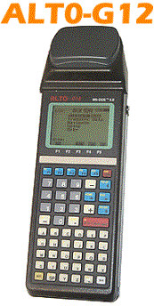
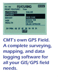
CMT
Field Software v3.8 Obtain 2 cm + 2
ppm accuracy with Carrier Phase The
ALTO-G12-CM offers the ultimate in flexibility, allowing you to do a variety
of tasks. It can be used to record 1-3 meter data in addition to 2cm+2ppm
data. For example, if you have a job that requires 2cm+2ppm accuracy on the
property corners but only requires 1-3 meter accuracy on the streams running
through the property, the ALTO-G12 would be the perfect tool. It can perform
both tasks in the field without skipping a beat. In the past, you would have
needed two different types of GPS receivers to do this job. |
|
|
||||||||||||||||||||||||||||||||||||||||||||
|
|
|
|
|
|
||||||||||||||||||||||||||||||||||||||||||||
|
|
|
The ALTO-G12 package includes CMT's PC-GPS software for comprehensive GPS project management and mapping. PC-GPS 05 provides functions for Mapping, Mission Planning, Batch Differential Correction, Static Point "Spread" analysis and Job Editing. The software also supports GIS layering, raster images (i.e. DOQs, DRGs, aerial photographs, satellite imagery), multimedia objects (OLE 2.0) and Microsoft® ODBC. System Accuracy Specifications
|
|
|||||||||||||||||||||||||||||||||||||||||||||
|
|
|
|
|
|
|
|||||||||||||||||||||||||||||||||||||||||||
|
|
|
|
|
|
||||||||||||||||||||||||||||||||||||||||||||