|
|
|
|
|
|
|
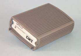
The most accurate L1
single-frequency GPS receiver (30 cm RMS) available.
Carrier phase capable of
achieving 1 cm + 1 ppm accuracy with long occupation times.
Recommended by CMT for use as a very reliable, high-precision base
station.
When compared to Trimble
Pro XRS, it provides better accuracy and a more powerful software solution. Efficient and Precise.
With a long base line
distance, such as 300 KILOMETERS, and one
minute of static measurements, you can achieve 30
CENTIMETER accuracy. Very useful for asset surveys. |
|

|

|
|
|
|
|
|
|
|
List Price: |
$6,450.00 |
$7,150.00 |
|
|
GPS receiver: |
12 channel |
12 channel |
|
|
DGPS Beacon Receiver: |
No |
Yes |
|
|
Professional GPS/GIS: |
Yes |
Yes |
|
|
Mapping Accuracy:
(Differentially
Corrected, 2DRMS) |
C/A Code: 25 -
50 cm
Carrier
Phase: 1 cm + 1 ppm |
|
|
Designed for easy use: |
Yes, CMT Field 3.8 Included |
|
|
On-board
Traverse: |
Yes |
Yes |
|
|
Post Processing: |
Yes
|
Yes |
|
|
Memory: |
4 MB standard
8
MB optional |
4 MB standard
8
MB optional |
|
|
Records Points,
Lines, and Areas: |
Yes |
Yes |
|
|
GPS/GIS Mapping
Software:
Microsoft
Windows® based |
Yes, PC-GPS 05 Included |
|
|
Waterproof: |
Yes, submersible |
Yes, submersible |
|
|
Audible beeper signal: |
Yes |
Yes |
|
|
|
|
|
|
|
System Features
- 12-channel L1 frequency
- Extremely stable pseudorange code & phase
measurements
- Full wavelength carrier phase on L1
- Carrier-phase smoothing
- Up to 2 Hz position update rate
- Up to 10 Hz code & phase measurements- 12-channel L1
frequency
- 1 PPS timing signal
- Superior performance under tree canopy |
|
|
|
|
NMEA
/ Barcode Device Interface Capabilities
- Two 9-pin
RS-232 serial ports, PC/AT pinout.
- The HP-GPS-L4 has two waterproof DB-9 RS-232 serial ports (COM1: and COM2:)
for communication with your PC as well as a variety of additional input and
output devices such as:
RTCM-104 Version
2.0: Real-time DGPS
Simply plug your RTCM-104 source (i.e. FM pager, VHF radio, WADGPS) into the
HP-GPS-L4's 9400 GPS Receiver. The HP-GPS-L4 will automatically detect and
use the RTCM message. Since the HP-GPS-L4 has two DB-9 serial ports, you can
use COM1: for RTCM and still have COM2: available for a barcode reader or
NMEA output to another instrument. Don't worry if you lose the RTCM message
while you are collecting data; the HP-GPS-L4 can be set to collect raw data
and will automatically warn you so you can post-process your data.
Compatible with
Coast Guard Beacon Receiver
Obtain real-time
differential correction with CMT's Coast Guard Beacon
Receiver package.
NMEA 0183
output
The HP-GPS-L4
will send out a NMEA 0183 message, at an interval specified by you to COM2:.
This functionality allows the HP-GPS-L4 to output a GPS position to devices
(i.e. digital cameras, sonar, etc.) that will accept a NMEA 0183 message.
There is no need to change your instrument settings. The HP-GPS-L4
communications can be set to match your instrument. In the NMEA Setup screen,
you have complete control over the baud rate and protocol settings.
Efficient Data
Entry with Bar Code Input
Attach a bar code
scanner to the HP-GPS-L4 and you can quickly enter data. Bar code menus can
be set up in such a way that you never need to touch the PC5L keyboard.
|
|
|
|
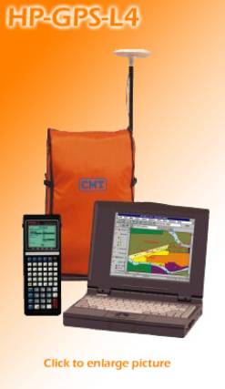
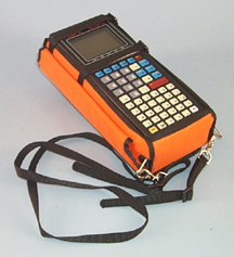
PC5L
Data Collector
with CMT
Field v3.8
- Waterproof
(submersible)
- Operating temperature: -40°C to 54°C
- 4 MB RAM standard (8 MB optional)
- 16 line x 25 character backlit display
- Interfaces to laser rangefinders, barcode readers and various NMEA devices
- Two 9-pin RS-232 serial ports, PC/AT pinout |
|
|
|
|
|
|
|
|
|
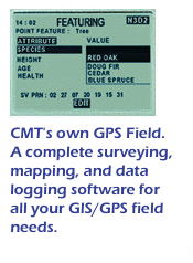
CMT
Field Software v3.8
- Collect Points, Lines
Areas
- Feature/Attribute/Value GIS structure
- Graphic plotting.
- Traversing keyboard data entry to allow you to continue mapping
when GPS is obstructed
- Offset function to map hard-to-reach locations.
- Nested point function for tagging points while you are mapping a Line or
Area Feature.
- Averaging function to optimize accuracy while recording static points.
- LLA/UTM/SPC plus user-defined coordinates.
- Supports 50 datums plus user-defined datums.
- Provides area calculation in the field
- Interfaces to laser rangefinders, barcode readers and various NMEA
devices
- Canyon, Blockage and Clear modes for optimal tracking performance
Obtain 2 cm + 2
ppm accuracy with Carrier Phase
Using carrier
phase, the HP-GPS-L4-CM can attain centimeter-level accuracy (2cm+2ppm)
without separate data collectors, antennas or poles. Uploading and processing
your carrier phase data in PC-GPS is virtually
the same as processing C/A code data. Behind the scenes, however, is a robust
carrier phase processor (CMTCM) that will provide either a FIXED solution
(ambiguities fixed to integers) or FLOAT solution (ambiguities resolved to
real values). The program will notify you of which type of solution was used.
You may also process the same data with the standard C/A code processor by
simply selecting the CMT Differential processor.
The HP-GPS-L4-CM offers
the ultimate in flexibility, allowing you to do a variety of tasks. It can be
used to record 1-3 meter data in addition to 2cm+2ppm data. For example, if
you have a job that requires 2cm+2ppm accuracy on the property corners but
only requires 1-3 meter accuracy on the streams running through the property,
the HP-GPS-L4 would be the perfect tool. It can perform both tasks in the
field without skipping a beat. In the past, you would have needed two
different types of GPS receivers to do this job. |
|
|
|
|
|
|
|
|
|

The HP-GPS-L4 package
includes CMT's PC-GPS
software for comprehensive GPS project management and mapping. PC-GPS provides
functions for Mapping, Mission Planning, Batch Differential Correction,
Static Point "Spread" analysis and Job Editing. The software also
supports GIS layering, raster images (i.e. DOQs, DRGs, aerial photographs,
satellite imagery), multimedia objects (OLE 2.0) and Microsoft®
ODBC.
System
Accuracy Specifications
|
Real-Time
Differential (DGPS): |
|
DGPS
(RMS) |
30 cm |
|
DGPS
(typical) |
30 - 60
cm |
|
|
|
|
L1
Carrier Phase Post-Processing: |
|
Static
(RMS) |
1cm +
1ppm |
|
Static
(typical) |
20 - 50
cm |
|
|
|
|
L1
C/A Code Post-Processing: |
|
Static
(RMS) |
30 cm |
|
Static
(typical) |
20-50
cm |
|
Time to
first fix |
60 sec.
typical, 40 sec. with
current ephemeris |
|
Dynamics |
3G |
|
Velocity
(RMS) |
.05
m/sec. |
|
Maximum
velocity |
460
m/sec. |
|
Maximum
altitude |
18000 m |
|
Physical |
|
|
Operating
temperature: |
-20°C
to 50°C |
|
|
Power
consumption: |
6 watts |
|
|
Input
voltage: |
10-32
VDC |
|
|
Humidity: |
95%
non-condensing |
|
|
|
|
|
