In a nutshell, GPS is based on satellite ranging - calculating the distances between the receiver and the position of 3 or more satellites (4 or more if elevation is desired) and then applying some good old mathematics. Assuming the positions of the satellites are known, the location of the receiver can be calculated by determining the distance from each of the satellites to the receiver. GPS takes these 3 or more known references and measured distances and “triangulates” an additional position.
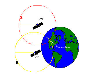
As an example, assume that I have asked you to find me at a stationary position based upon a few clues which I am willing to give you. First, I tell you that I am exactly 10 miles away from your house. You would know I am somewhere on the perimeter of a sphere that has an origin as your house and a radius of 10 miles. With this information alone, you would have a difficult time to find me since there are an infinite number of locations on the perimeter of that sphere.
Second, I tell you that I am also exactly 12 miles away from the ABC Grocery Store. Now you can define a second sphere with its origin at the store and a radius of 12 miles. You know that I am located somewhere in the space where the perimeters of these two spheres intersect - but there are still many possibilities to define my location.
Adding additional spheres will further reduce the number of possible locations. In fact, a third origin and distance (I tell you am 8 miles away from the City Clock) narrows my position down to just 2 points. By adding one more sphere, you can pinpoint my exact location. Actually, the 4th sphere may not be necessary. One of the possibilities may not make sense, and therefore can be eliminated.
For example, if you know I am above sea level, you can reject a point that has negative elevation. Mathematics and computers allow us to determine the correct point with only 3 satellites.
Based on this example, you can see that you need to know the following information in order to compute your position:
A) What is the precise location of three or more known points (GPS satellites)?
B) What is the distance between the known points and the position of the GPS receiver?
Go back to the previous chapter: What is GPS?
Go on to the next chapter: How the Current Location of GPS Satellites is Determined
Return to the Table of Contents
CMTINC.COM |
|||
Tel: (541)752-5456 |
Fax: (541)752-4117 |
||
© Corvallis Microtechnology, Inc. 2000 All Rights Reserved |
|||