|
|
|
|
|
|
|
|||||||||
| |
|
|
|
|
|
|||||||||
| |
|
CMT
offers the most user-friendly tree inventory data collection software
for both the field and office. 1) PC-Cruise is used in
the office to manage your tract and stand maps as well as to set up
your timber cruise. 2) Use CE Cruise in the field on a Windows
CE PDA unit for the latest in GPS/GIS based timber cruising data collection.
3) PC-Cruise takes over
back in the office for quantity calculations and report output as well
as integration into your GIS system.
Supported cruise methods include: |
|
|
|
|
|
|
||||||
|
|
|
|
|
|
|
|
||||||||
|
PC-Cruise is designed to be powerful and easy to use. PC-Cruise is a super-set of PC-GIS, PC-GPS and PC-Mapper. Therefore, you will find all of the mapping functions and Forester's tools that you need in the PC-Cruise software. |
||||||||||||||
Major innovation: GPS/GIS
Based Timber Cruising PC-Cruise is the only software product, which combines GPS mapping, GIS data management, and timber cruising data collection into a single user-friendly software package. |
||||||||||||||
 |
||||||||||||||
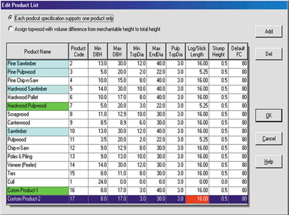
CALCULATIONS
Specify up to two different methods
for calculating the volume/weight for each timber product. Choose from the following:
|
||||||||||||||
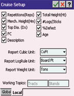
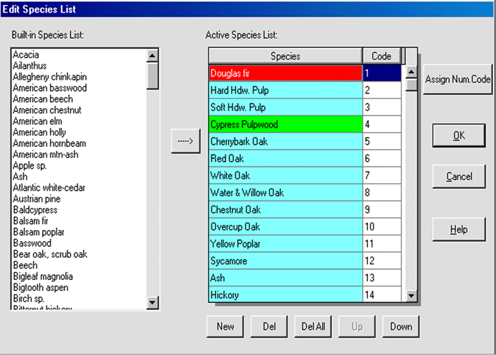
SETUP
Add species and code them in one easy step! |
||||||||||||||
 |
||||||||||||||
|
Assign products and parameters for your cruises. |
||||||||||||||
 |
||||||||||||||
REPORTS
Many report formats available: |
||||||||||||||
|
||||||||||||||
|
||||||||||||||
|
|
|
|
|
|
|
|
||||||||
|
|
|
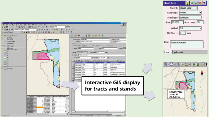
Cruising Grid Setup and Navigation to Plots Timber cruisers today demand an efficient method of establishing stand boundaries, setting up cruising plots and then collecting and reporting tree data cruise data. CMT meets this demand by providing simple and flexible data collection and cruising grid setup tools. |
|
|
|
|
|
|||||||
|
|
||||||||||||||
|
|
|
|
|
|
|
|
|
|||||||
|
|
|
Land Owner Information Keep track of landowner and stand location in the field or office. Valuable information about location such as section, township and range are available along with address information to help track stand locations. Separate fields for Cruiser ID and Date help manage data for combining cruises back in the office in PC-Cruise.
|
|
|
|
|
|
|||||||
|
|
||||||||||||||
|
|
|
|
|
|
|
|||||||||
|
|
Quality Checking for tree data input Eliminate mistakes made in the field with on-board error checking. Data entered in the field is checked in real-time against pre-defined acceptable parameters for tree species and product. Users are warned when data is outside of acceptable ranges. |
|
|
|
|
|||||||||
|
|
|
|
|
|
|
|||||||||
|
|
|
Customized data entry fields Save time in the field by collecting only the data that is important to you. The included office software: PC-Cruise allows you to turn on and off those data fields that you want to store. By turning off unnecessary data fields, you can cut your cruising time down significantly. |
|
|
|
|
|
|
|
|||||
|
|
|
|
|
|
|
|
|
|
|
|||||
|
|
|
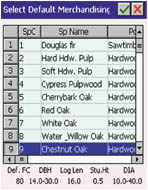
Specify defaults for Data Entry Yet another way to save time in the field is to set up and use "defaults". These items will be the firs thing displayed for a particular data entry field. This is very valuable for plantation stands or stands with very little variety. The most common species and product will show up first, so you do not have to scroll through the list each time to pick the species and product. |
|
|
|
|
|
|
|
|||||
|
|
|
|
|
|
|
|
|
|
|
|||||
|
|
|
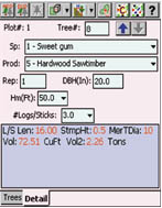
Quick and Easy Menus The CE Cruise software is set up to minimize keystrokes in the field. Data fields can be keyed in or you can use the pull-down menus to quickly select the desired input. |
|
|
|
|
|
|
|
|||||
|
|
|
|
|
|
|
|||||||||
|
|
|
Availability: For your PC, you can upgrade your
existing PC-GIS, PC-GPS, or PC-Mapper software to the PC-Cruise software.
PC Cruise is the super set of these other software packages, so you
will still have all of the functionality offered by these previous versions.
On the field side, you can upgrade your existing MapPad
or Field CE GIS software to upgrade to the CE Cruise software. CE Cruise
is the super set of these other field software packages, so you will
still have all of the functionality offered by these previous versions.
|
|
|
|
|
|
|
|
|||||
| |
|
|
|
|
|
|||||||||
|
|
|
Download
a printable brochure here
©CMTINC.COM 2007 |
|
|
|
|||||||||