|
|
Thousands of Patterns
|
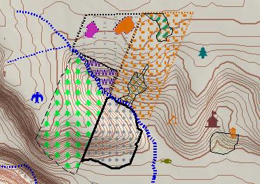
CMT BaseMap with
Contour Lines |
|
|
|
|
|
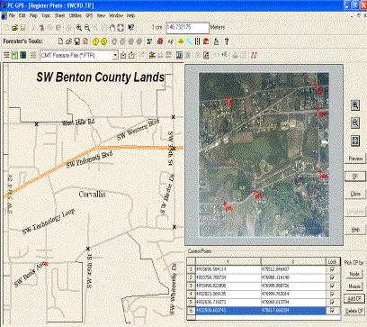
Aerial Photo Support, Register Photos and Link Media |
|
HIGHLIGHTS
4
BaseMaps
w/ contour lines
4
GIS
functions: Split, Join & more
4
Buffering for points, lines & areas
4
Image
support for: MRSID® format, JPEG2000, GeoJPEG & GeoTIFF
4
Heads-up
digitizing
4
Easy
to Learn & Friendly to Use
4
Forester’s Toolkit included
4
GPS
Navigation
4
Interactive spreadsheet
4
Huge
symbol/pattern library |
|
|
|
|
|
PC-GIS has a complete GIS interface:
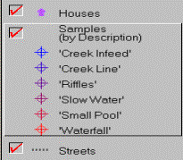
4 Topic
View is used to control layer
order, legends, classification schemes and automatic labeling |
|
|
4
Map View displays your map with
different symbols, background maps, aerial photos and linked media |
|
|
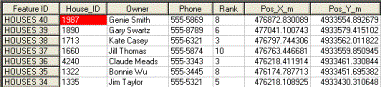
4
Sheet View is a spreadsheet
containing a database of attributes/values used for queries, sorting &
reports |
|
Also find these powerful features in PC-GIS:
Georeferenced Image Support
Import and display Geotiffs, GeoJPEGs (NEW), JPEG2000s and MRSID®
format images into your Map. Use DOQ, DRG, or custom aerial photography to
enhance your GIS data. Also, PC-GIS offers an improved interface for
georeferencing of TIF, JPG, and BMP image files.
Professional Plotting Output
Produce professional-looking maps using either the Quick Plot option or
Custom Plot option. Use drag and drop placement for your company logo,
headers, footers, legends, and other text. Includes standard mapping features
such as: legends, scale bars, and north arrows. Once the plot format is
complete, you can save the layout for future use. Also, plot directly to an
image file.
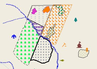
Symbol and Pattern Libraries
Customize your map using symbols and patterns. For standard symbols, PC-GIS
offers multiple libraries to choose from (including transparent hatch
patterns). You can also combine existing symbols to create your own symbols.
Geographic Feature Search
Search for Features within a user-defined area. Search three ways: 1) by
Radius from given Point or 2) for Points contained in specific Area Features;
or 3) by Entire Map.
Enhanced Classification
Classify by unique value, equal interval, quantile, or custom classification
scheme. Assign symbols and patterns to classes.
Cumulative and Bearing Measurements
Measure cumulative distance between features and also get valuable heading
information.
Enhanced Topic Identification
Separate Topic name for each Feature collected by GPS based on Feature name.
Registered imagery is also assigned to its own Topic based on its file name.
User-Friendly Icons
Icons for Measure Area, Measure Length, Measure Distance, Coordinate
Information, Display Photo, Shape Property and more.
Define your own Coordinate Systems
Use this powerful feature of PC-GIS to create your own coordinate system or
datum for your jobs.
Feature Data Import: ASCII, Shape file, DXF
PC-GIS allows you to supplement (import) your GPS maps with Feature data from
a variety of data sources: ArcView® Shapefiles, AutoCAD®
DXF files, ASCII and other PC-GIS Job files.
Once your map is complete, the Feature data can be exported into several
different GIS and database formats (ESRI Shapefile, DXF, ASCII, MS ODBC,
Intergraph Microstation). Simply select the export format from the
pull-down Data Source box and then click on the export icon.
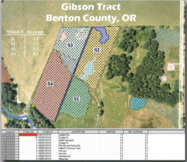
Powerful Mapping Functions
Your Map can be created using a variety of data sources: GPS Feature files,
DXF files, ASCII Files, ESRI® Shapefiles (.SHP), databases, and
digital images. The geographic and image data in your Map is automatically
organized into layers to facilitate map viewing and data management. Your
completed Map can be displayed in UTM, SPC, LLA or even a user-defined
Coordinate System.
Once your Map is created, it can be plotted complete with custom legends,
labels and objects. Each Feature in the Map can be labeled by Feature name or
by specific value. Tailor the size, style or color of labels shapes and text
to suit your needs.
Impressive Visual Tools: Images & Objects
PC-GIS enhances your data with digital images (.BMP, .JPG, .TIF) and even multimedia
objects conforming to Microsoft's® OLE standard. Images, such as
aerial photos, can be georeferenced to your Map within PC-GIS. Create new
Features from your image using "heads-up digitizing". Vividly
describe Features by linking descriptive objects like video/audio clips,
documents and spreadsheets to a specific Point, Line or Area.
Resource and Data Management
PC-GIS offers a number of powerful data analysis and management functions.
Analyze the Feature, Attribute and Value data in your Map using powerful
Filter, Search and Classification tools. With classification, you can create
data subgroups or color-coded classes. Calculate Feature areas and lengths or
measure map distances at the click of a button. View your attribute and value
data in spreadsheet form for quick reference and editing.
Export Feature Data from PC-GIS to your Database Program
If you need to perform more extensive analysis or reporting functions, export
your map data directly to a number of databases such as Access®,
dBASE®, FoxPro® and other Microsoft® ODBC
compliant programs. PC-GIS data can then be joined with your existing GIS
database. Finally, you can import all your data, or only a portion of data,
back into PC-GIS.
ADDITIONAL
INFORMATION
PC-GIS combines CMT's proven GIS project management utilities with powerful
mapping functions in one package. It can be used as part of a complete system
with a CMT GPS data collector or as a stand-alone resource-mapping program.
Best of all, you don't need to be a GIS expert to use PC-GIS. Many of the
functions available in more complicated GIS or mapping programs are readily
accessible and easy to learn. When you need advanced capabilities, PC-GIS
provides power beyond standard mapping programs with the support of
Microsoft's®; Open DataBase Connectivity (ODBC), Object Linking
& Embedding (OLE), and Advanced Programming Interface (API).
Download a printable brochure here
|