|
|
PC-GPS 07
Choose from the following options.
Standard Features
Price List
Additional Information
Version Comparison
If you have a question or technical
issue that is not addressed by this section, please contact us at
support@cmtinc.com
|
|
STANDARD FEATURES
Batch
Differential Wizard
User-friendly GPS post-processing wizard. Provides an interactive, step-by-step
environment for differentially correcting GPS data. The Wizard will
automatically connect to the internet and locate the closest NGS CORS base
station to where you collected your data and then download the necessary
files. After correction, the troubleshooting Wizard will recommend procedures
for correcting any uncorrected coordinates. You can use the Wizard to
post-process one or multiple GPS jobs in a single session.
Geo-Tiff Support
Import and
display georeferenced TIF files into your Map. Use DOQ, DRG, or other
Geotiff files to enhance your map. Also, you can create your own Geotiffs
with the improved georeferencing function. NEW!! MrSID® format support, GeoJPEG and JPEG2000 format
support.
Professional
Plotting Output
Produce professional-looking
maps using either the Quick Plot option or Custom Plot option. Use drag and
drop placement for your company logo, headers, footers, legends, and other
text. Includes standard mapping features such as: legends, scale bars, and
north arrows. Once the plot format is complete, you can save the layout for
future use. Further customize your plots with company logos and acreage
summaries for polygons.
Symbol and
Pattern Libraries
Customize
your map using symbols and patterns. For standard symbols, PC-GPS offers:
thousands of Point Symbols, Line and Area Patterns (including transparent
hatch patterns). You can also easily create your own symbols or choose
any other font library for a whole new library of symbols.
Geographic
Feature Queries
Search for Features
within a user-defined area. Search three ways: 1) by Radius from given Point
or 2) for Points contained in specific Area Features; or 3) by Entire Map.
Perform advanced conditional queries using *AND* / *OR* operands.
Enhanced
Classification
Classify your
data in a variety of ways: unique value, equal interval, quantile, or custom
classification. Assign symbols and patterns to classes.
Area/Length and
User-Defined Equation Attributes
Select Acreage or
Length to be automatically added as Feature Attributes. Then, you can label
or classify your Features according to Acreage or Length. Create User-Defined
Equations to calculate Feature Attributes based on the values of other
Feature Attributes.
Cumulative
Measurements
Measure
cumulative distance between several features.
Enhanced Topic
Identification
Separate Topic
name for each Feature collected by GPS based on Feature name. Each Geo-Tiff
is assigned to its own Topic based on its file name.
More
User-Friendly Icons
Icons for Measure
Area, Measure Length, Measure Distance, Coordinate Information, Display
Photo, Shape Property and more.
Define
your own Coordinate Systems
Use this
powerful feature of PC-GPS 3.8 to create your own coordinate system or datum
for your jobs.
Static
Point Analysis or "Spread" Function
The Spread
Function allows you to view and edit the individual GPS fixes of your static
GPS Points. GPS fixes can be cut based on DOPs, Residual, Number of
Satellites, or even RMS, 2DRMS. Ultimately, the Spread Function allows you to
compare and improve the accuracy of your GPS Static Points.
You will see a graphic display of your averaged GPS Point and the
"spread" of all of the individual GPS fixes. The File/Point Summary
function can be used to access a text report summarizing each GPS position
fix: position, DOP, residual, SV Num as well as the Point’s
Horizontal/Vertical RMS and 2DRMS.
Feature Data
Import: ASCII, Shape file, DXF
PC-GPS allows
you to supplement (import) your GPS maps with Feature data from a variety
of data sources: ArcView® Shape files, AutoCAD®
DXF files, ASCII and other PC-GPS Job files.
Once your map is complete, the Feature data can be exported into several
different GIS and database formats (ESRI Shape file, DXF, ASCII, MS ODBC,
Intergraph Microstation). Simply select the export format from the
pull-down Data Source box and then click on the export icon.
Powerful Mapping
Functions
Your Map can be
created using a variety of data sources: GPS Feature files, DXF files, ASCII
Files, ESRI® Shapefiles (.SHP), databases, and digital images. The
geographic and image data in your Map is automatically organized into layers
to facilitate map viewing and data management. Your completed Map can be
displayed in UTM, SPC, LLA or even a user-defined Coordinate System.
Once your Map is created,
it can be plotted complete with custom legends, labels and objects. Each
Feature in the Map can be labeled by Feature name or by specific value.
Tailor the size, style or color of labels shapes and text to suit your needs.
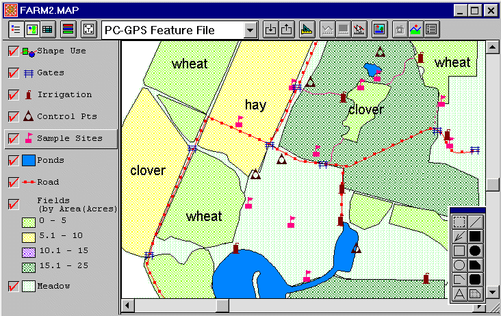
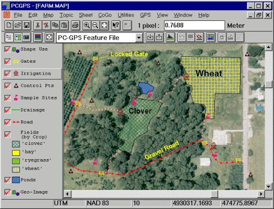
View a complete PC-GPS Map
Direct Digital
Camera Interface
The "Photo"
function allows you to download photos from a Kodak digital camera and
attach photo images to Features in the Map. This function also works
with existing photos in a .JPG, .BMP or .TIF files. Click the Photo button to view the
images associated with your Features.
GPS Processing
If you have
a GPS data collector, PC-GPS can help you manage your GPS data collection
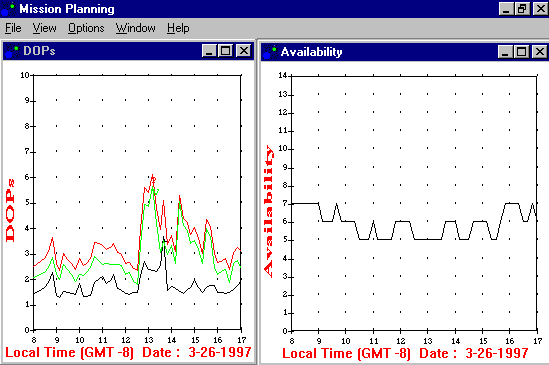
"jobs" from start to finish. Prior to field data collection,
you may identify optimal times for GPS reception using Mission Planning.
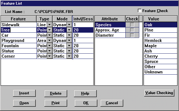
In addition, you may want to construct a "Feature List" of
Features, Attributes, and Values to promote organized and convenient
field data collection. Following GPS collection, use our advanced differential
correction to improve the accuracy of your GPS data. Finally, export
your data to your GIS system or create a complete map within PC-GPS.
View a Feature List Example
View a Mission Planning Example
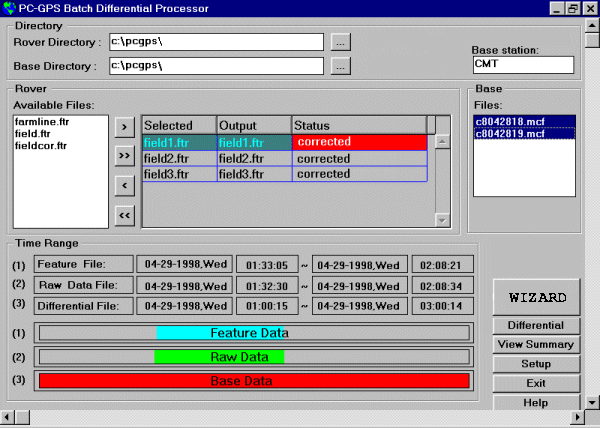
View a GPS Corrections Example
Impressive Visual
Tools: Images & Objects
PC-GPS enhances
your data with digital images (.BMP, .JPG, .TIF) and even multimedia
objects conforming to Microsoft's® OLE standard. Images,
such as aerial photos, can be georeferenced to your Map within PC-GPS.
Create new Features from your image using "heads-up digitizing".
Vividly describe Features by linking descriptive objects like video/audio
clips, documents and spreadsheets to a specific Point, Line or Area.
View a PC-GPS Map with a georeferenced aerial
photograph
Resource and Data
Management
PC-GPS offers
a number of powerful data analysis and management functions. Analyze
the Feature, Attribute and Value data in your Map using powerful Filter,
Search and Classification tools. With classification, you can create
data subgroups or color-coded classes. Calculate Feature areas and lengths
or measure map distances at the click of a button. View your attribute
and value data in spreadsheet form for quick reference and editing.
Export Feature
Data from PC-GPS to your Database Program
If you need
to perform more extensive analysis or reporting functions, export your
map data directly to a number of databases such as Access®,
dBASE®, Foxpro® and other Microsoft®
ODBC compliant programs. PC-GPS data can then be joined with your existing
GIS database. Finally, you can import all your data, or only a portion
of data, back into PC-GPS.
PRICE
LIST
|
PC-GPS 05 upgrade
|
to 07
w/ Forester's Toolkit
|
$ 185.00
|
| PC-GPS
3.8 upgrade
|
to 07
w/ Forester's Toolkit
|
$ 385.00
|
| PC-GPS
3.7or 3.X upgrade
|
to 07
w/ Forester's Toolkit
|
$ 485.00
|
|
|
|
|
|
|
|
|
|
PC-GPS 07 w/ Forester's
Toolkit Complete Package
|
$ 1,485.00
|
For Questions or to
Order, email CMT at support@cmtinc.com
ADDITIONAL
INFORMATION
PC-GPS combines CMT's proven GPS project management utilities with powerful
mapping functions in one package. It can be used as part of a complete
system with a CMT GPS data collector or as a stand-alone resource-mapping
program.
Best of all, you don't need to be a GIS expert to use PC-GPS.
Many of the functions available in more complicated GIS or mapping programs
are readily accessible and easy to learn. When you need advanced capabilities,
PC-GPS provides power beyond standard mapping programs with the support
of Microsoft's®; Open DataBase Connectivity (ODBC), Object
Linking & Embedding (OLE), and Advanced Programming Interface (API).
PC-GPS
Specifications
|
|
|