|
|

|
|
|
|
|
List Price:
|
$26,885.00
|
|
GPS receiver:
|
12-channel L1 /
12-channel L2
|
|
Professional GPS/GIS:
|
Yes
|
|
Mapping Accuracy:
|
RTK: 1 cm +
1 ppm
Post
Process Static: 5 mm + 1 ppm
|
|
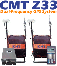
Field System:
|
PC5L©
Hand-held
with 8
Megabyte RAM and 1MB Flash EEPROM
Dual-Frequency
GPS Rover Backpack
with
RTK Radio, Dual Frequency Receiver, GPS Antenna, Rover Backpack
|
|
Designed for easy
use:
|
Yes, CMT Field 4.2 Included
RTK,
OTF, Static, Stakeout, Geoid 99 Model in field
|
|
On-board Traverse:
|
Yes
|
|
Post Processing:
|
Yes
|
|
Memory:
|
8
MB
standard
|
|
Records Points,
Lines, and Areas:
|
Yes
|
|
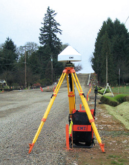
Base Unit:
|
Dual-Frequency GPS
Base unit
with
RTK Radio, Dual Frequency Receiver, GPS Antenna
WinBase - Base Station
Software
|
|
GPS/GIS Mapping
Software:
Microsoft
Windows® based
|
Yes, PC-Mapper 07
Included
|
|
Waterproof:
|
Yes, submersible
|
|
|
|
|
|
 System Features
- 12-channel L1 / 12-channel
L2
- Full wavelength carrier phase on L1 and L2
- P-code on L1 and L2
- Z-Tracking
- L1 C/A code
- On-the-fly (OTF) initialization
- Real-Time Kinematic for Position accuracy: 2cm +1ppm
- Operational under Anti-spoofing (AS) conditions
- Up to 13db signal-to-noise advantage over cross correlation for tracking
weaker satellite signals
- Fast signal acquisition and reacquisition algorithms
- Low data latency
- Up to 10Hz position and raw data rate
- Real-time data output
- RTCM-SC104 V.2.1 for DGPS and RTK
- RINEX Ver. 2.0
- NMEA 0183 V.2.01
- 1 PPS timing signal
- Event marker
- Static - Carrier Phase Differential Position accuracy: 5mm + 1ppm
NMEA
/ Barcode Device Interface Capabilities
- Two 9-pin RS-232 serial
ports, PC/AT pinout.
- The Z33's PC5L has two waterproof DB-9 RS-232 serial ports (COM1: and
COM2:) for communication with your PC as well as a variety of additional
input and output devices such as:
NMEA 0183
output
The Z33's PC5L will send out a NMEA 0183 message, at an interval specified by
you, to either COM1: or COM2:. This functionality allows the Z33's PC5L to
output a GPS position to devices (i.e. digital cameras, sonar, etc.) that
will accept a NMEA 0183 message. There is no need to change your instrument
settings. The Z33's PC5L communications can be set to match your instrument.
In the NMEA Setup screen, you have complete control over the baud rate and
protocol settings.
Efficient Data
Entry with Bar Code Input
Attach a bar code scanner to the Z33's PC5L and you can quickly enter data.
Bar code menus can be set up in such a way that you never need to touch the
PC5L keyboard.
|
|
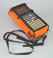 PC5L Data Collector
with CMT Field v4.2
- Waterproof
(submersible)
- Operating temperature: -40°C to 54°C
- 8 MB RAM standard, 1 MB Flash EPROM
- 2D/3D point, offset, slope staking
- CoGo, traverse, inverse, intersect, horizontal curve, create line,
create arc, 3-point curve
- NEZ calibration for working on local planes
- LLA/UTM/SPC plus user-defined coordinates
- Supports 50 datums plus user-defined datums
- Geoid 99 model on-board for accurate MSL in the field
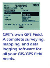 CMT Field Software
v4.2
CMT Field Software
v4.2
- Collect Points, Lines
Areas
- Feature/Attribute/Value GIS structure
- Graphic plotting.
- Traversing - keyboard data entry to allow you to continue mapping
when GPS is obstructed
- Offset function to map hard-to-reach locations.
- Nested point function for tagging points while you are mapping a Line or
Area Feature.
- Averaging function to optimize accuracy while recording static points.
- LLA/UTM/SPC plus user-defined coordinates.
- Supports 50 datums plus user-defined datums.
- Provides area calculation in the field
- Interfaces to laser rangefinders, barcode readers and various NMEA
devices
- Canyon, Blockage and Clear modes for optimal tracking performance

The Z33 System package
includes CMT's PC-Mapper software for comprehensive GPS
project management and mapping. PC-Mapper provides functions for Mapping,
Mission Planning, Batch Differential Correction, Static Point
"Spread" analysis and Job Editing. The software also supports GIS
layering, raster images (i.e. DOQs, DRGs, aerial photographs, satellite
imagery), multimedia objects (OLE 2.0) and Microsoft® ODBC.
System
Accuracy Specifications
|
RTK
|
|
Static
Horizontal (RMS):
|
1 cm +
1ppm
|
|
Static
Vertical (RMS):
|
1.7 cm
+ 1ppm
|
|
Min.
Static occupation time:
Sub-centimeter
accuracy with longer occupation time.
|
2
seconds
|
|
Kinematic
Horizontal (RMS):
|
3 cm +
1 ppm
|
|
Kinematic
Vertical (RMS):
|
5 cm +
1 ppm
|
|
Azimuth
(arc sec):
|
.15 +
1.5/baseline length in km
|
|
Initialization
time to fix ambiguities:
|
Low as
10 sec after P-code
lock on 8 satellites
|
|
|
|
|
Real-time
Differential (DGPS)
|
|
DGPS
(RMS)
|
<1 m
+ 10 ppm
|
|
|
|
|
L1/L2
Carrier Phase Post-processing
|
|
Static
(RMS):
|
5 mm +
1 ppm
|
|
Kinematic
(RMS):
|
1 cm +
1 ppm
|
|
|
|
|
L1
C/A code post-processing
|
|
DGPS
(RMS):
|
<1 m
+ 10 ppm
|
|