|
|
|
|||||||
| COMPLETE Integration Works well with PC Tablet, Notebook, and Desktop computer. |
|
|||||||
| Utilize the Hottest Technology Use the
same tablet or notebook computer to meet all your Field & Office
needs!
|
|
|||||||
| Flexible GPS Input |
|
|||||||
| Virtually Unlimited Data Storage |
|
|||||||
| Easy to Learn |
|
|||||||
| High Precision Applications |
|
|||||||
GPS Features |
|
|||||||
| Field |
Office |
|
||||||
| Real-time Navigation - Supports Single &
Dual Frequency field corrections (RTCM-104 and RTK) |
Full range of Single & Dual Frequency Differential Correction
options: C/A Code, Static Phase, Kinematic (OTF) Phase |
|
||||||
|
Feature/Attribute/Value Mapping |
Point Spread Analysis, Statistical Quality Control |
|
||||||
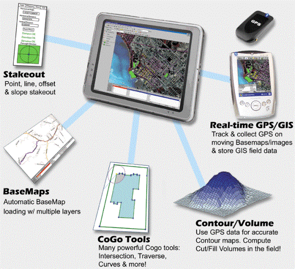
| Point/Offset/Slope Stakeout |
Interface
with CMT PDA GPS data collector |
|
||||||
| Traverse & Offset to continue mapping when
GPS signals are unavailable |
Average, Join, Split, Buffer and other utilities |
|
||||||
GIS Features |
|
|||||||
| Field |
Office |
|
||||||
| Digital Inspection - Record and link digital
photography and video to features. |
Import/Export in popular GIS formats, including ArcView, AutoCAD,
ASCII and more! Import/export from/to Excel or Access. Supports
ODBC for import/export from/to dBase and more! |
|
||||||
| On-the-fly coordinate system conversion |
Digitize over various background map formats. Image transparency
adjustment. Professional labeling, deed call text output and Map plotting. |
|
||||||
| Heads-up digitizing of new features with simple
mouse clicks |
Search & Classify data. Calculate lengths & areas with
a single mouse click. Automatically label data based on attributes/values. |
|
||||||
|
|
||||||||
| PC-Mapper 09 List Price: |
$1,485.00 |
|
||||||
| PC- Mapper Upgrade Pricing Table
|
|
|||||||
| Upgrading From: |
Upgrading to: |
List Price: |
|
|||||
| PC-Mapper 07 |
PC-Mapper 09 |
$185.00 |
|
|||||
| PC-Mapper 5.X |
PC-Mapper 09
|
$385.00 |
|
|||||
Special Educational package
|
||||||||
• PC-MAPPER 09 software license
|
$985.00 |
|
||||||
|
|
||||||||
| PC-Mapper combines CMT's proven GPS project management utilities with powerful mapping functions in one package. It can be used as part of a complete system with a CMT GPS data collector or as a stand-alone resource-mapping program. PC-Mapper allows you
to add Geotiff, GeoJPEG, ECW and MRSID® format imagery, CMT BaseMaps and
customized symbols to your GPS maps! You can adjust the transparency of images layers and Area Features.
Our symbol library offers thousands of Point symbols, hundreds
of Line and Area patterns. Symbols and patterns can be quickly customized.
The new plotting interface features drag & drop placement/sizing
for your headers, footers, legends, etc. Includes improved plot scale
options. Print out the completed map or save it to a JPEG or PDF file. Best of all, you
don't need to be a GIS expert to use PC-Mapper. Many of the functions available in more complicated
GIS or mapping programs are readily accessible and easy to learn. When
you need advanced capabilities, PC-Mapper provides power beyond standard
mapping programs with the support of Microsoft's® Open DataBase
Connectivity (ODBC), and Object Linking & Embedding (OLE). |
|
|||||||
|
|
||||||||
|
Simulations
of Navigation: |
|
|||||||
|
|
||||||||
|
|
||||||||
|
Download a printable brochure here |
|
|||||||
| |
|
|||||||