|
|
CMT Survey
|
|
|
|
CMT Survey offers an all-in-one package
for surveyors. This GPS/GIS/Survey/Contour/Volume/Coordinate Geometry/CAD
software offers all the tools needed by today’s surveying professionals. All
of these tools are conveniently combined into one package!! Designed for use on a Tablet PC
or notebook PC, you can take CMT Survey with you and all of your data as
well. Whether you need to Stakeout points, shoot some side shots with your
Total Station or perform RTK GPS Mapping, CMT Survey can handle the job. |
|
|
|
|
|
|
|
CMT Survey offers a direct interface on your PC for the
following applications: ±
Total Station Interface ±
GPS/GIS Data Collection ± Navigation/Stakeout ±
CAD Design CMT Survey is a super-set of
PC-Mapper and PC-GPS so you will find all of the tools that you enjoy in
these other software packages. |
|
|
|
|
|
|
|
|
|
|
|
|
|
|
|
|||
|
|
Convenience and Power
|
|
||
|
|
CMT Survey is designed for Windows 2000/XP/Vista and Windows 7 Tablet PC supporting full 32-bit color and multi-media using Microsoft's OLE. With CMT Survey, you can run multiple jobs and functions on one computer. You can use the same computer to meet all of your Field & Office needs! TOTAL SOLUTION FROM START TO FINISH EASY TO LEARN AND FRIENDLY TO USE FLEXIBLE |
|
||
|
|
Powerful Map Labeling |
|
||
|
|
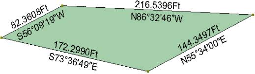
With CMT Survey, you can quickly and easily label all portions of your data with distance and angle information: |
|
||
|
|
Use these labeling functions: ± Segment
Labeling ± Marker
Labeling ± Angle
Labeling ± Area Labels |
|
|
|
|
|
|
|
|
|
|
|
Other Highlights |
|
||
|
|
The following enhancements have
been implemented in the CMT Survey 09 software:
4
Full customization of software tool bars and menu
items.
4
Ability
to create CONTOUR maps for a specific topic or create contour lines for a specific area.
4
Support for DEM (Digital Elevation Model) data
to create contour lines, 3D shaded relief overlays.
4
Create features from Deed Call text,
or create Deed Call text from existing features.
4
Create Cruising Grid Points or Lines with Offset option and different spacing in the x and y directions.
4
Ability
to attach Voice Recording to any
Feature in the map.
4
Import/Export Sheet
View data from/to Microsoft® Excel or Access.
4
Supports ASCII EXPORT of multiple Topics as well
as Line and Area features.
4
Use the Load Background Map function to load another job file
in the background to use as a guide for digitizing or reference. 4 Record Supplemental Data for each Feature Topic. Query historic and planning data and generate reports.
|
|
||
|
|
Download a printable brochure
here |
|
||
|
|
CMTINC.COM ã2010
|
|
||