Home

MS PowerPoint Presentation

Brochure

Demo Software

Function list

More Screen

Pricing


Advanced GPS/GIS Data Collection for CE PDA devices

New! Field CE GIS Enhancements:

  • Digital Elevation Model (DEM) to show contour lines on your BaseMap
  • Imagery in MRSID® format, GeoJPEG, JPEG 2000 and Geotiff formats
  • Clip irregular image shapes to assist in navigation or digitizing
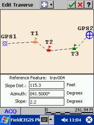
  • New user interface for Traverse function.
  • The same Point/Line/Area patterns as in PC-GPS (thousands available)
  • Intelligent GPS port recognition.
  • Free-hand digitizing capability line/area features
  • Improved interface for navigation and auto-routing.
  • Navigation to current road, next intersection, remaining distance and next turn
  • Snap to Node function for digitizing Points, Lines and Areas
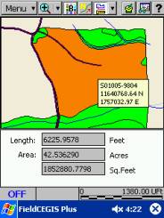
  • Get area calculations for areas that are formed by Line Features

Standard functions:

  • Shapefiles and image data
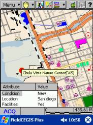
  • Detailed, colorful BaseMap background data
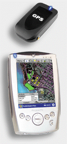
  • Wireless GPS and other data collection
  • Distance and Area measurements on the spot
  • Interface with desktop GIS
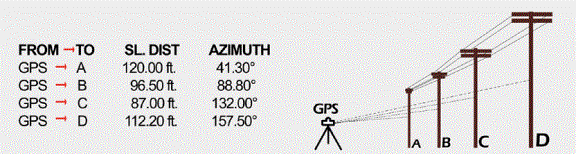
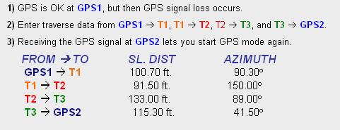
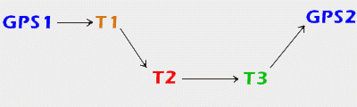
  • Offset points or Traverse points when GPS signal not available
  • Images: load aerial photos or topo maps in the background
  • Storage of GIS Feature, Attribute, and Value data
  • Point/Line/Area symbol and pattern libraries
  • Coordinate system conversion on the fly
Store Points along a Line or Area without padding the Line or Area Feature. For example,
map a road as a dynamic line, also record traffic signs along the road.
  • Raster & Vector
  • NEZ Plane Support
  • Offset & Traverse
  • Nested Points
  • Instant Coordinate update
  • Length & Area Measurement
  • NMEA-183 & GPS raw data
  • Heads-Up Digitizing
  • Real-Time & Post Process Differential
  • LLA/UTM/SPC & User Defined Coords
  • Logging Mode: By time, By Distance
  • Professional Integrated GPS/GIS
Length and Area Tool

Click a button to show length
and area for the selected feature

Traversing - Available only from CMT

Traverse a series of points when GPS is not available

GIS Information


Field CE provides a complex
GIS database on-board

The NEZ Plane - A necessity in professional packages

Merge traditional Northings and Eastings on a local plane, with GPS data (latitude/longitude)

1) Pick any point on the survey and assign 1000N, 1000E as its coordinates.

2) Go to that point and record a GPS position

(shown at A).

3) To produce the correct orientation and scale, pick one other point and record a GPS position

(shown at B).

B) GPS Control:     44°33´30.168457¨ N
                           123°18´31.679077¨ W
  NEZ Control:   1543.4117N, 1024.9288E
A) GPS Reference: 44°33´24.798889¨N
                           123°18´31.761475¨ W
  NEZ Reference: 1000.0000N, 1000.0000E
Field CE GIS also available for Dell Axim

Media Links:
View more screen samples here
Download a printable brochure here


Home

MS PowerPoint Presentation

Brochure

Demo Software

Function list

More Screen

Pricing