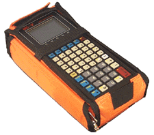
 Surveyor's
Assistant (SA) offers you a powerful and complete surveying software and
data collector system. Surveyor's Assistant is for the surveyor who needs
a data collector that is powerful and flexible, yet simple and helpful in
its operation. A number of unique features make the Surveyor's Assistant
the logical choice for seasoned users as well as newcomers to the world
of electronic data collection.
Surveyor's
Assistant (SA) offers you a powerful and complete surveying software and
data collector system. Surveyor's Assistant is for the surveyor who needs
a data collector that is powerful and flexible, yet simple and helpful in
its operation. A number of unique features make the Surveyor's Assistant
the logical choice for seasoned users as well as newcomers to the world
of electronic data collection.
- extensive coordinate geometry functions,
- complete Earthworks capabilities (SA 2.05 and SA 2.2),
- several data adjustment routines,
- staking functions to assists in road design,
- interactive on-screen graphics
- a fully functional and interactive RPN calculator (SA 2.05 and SA 2.2)
CMT's Complete Field to Office Survey Data Collection Solution
From the first time you use it, you will find that Surveyor's Assistant is the most user-friendly data collection software package available on today's market. Maximize your productivity with these features:
- The system is simple, yet powerful. No computer knowledge or experience is needed to operate it. To select a function, simply "point and shoot".
- Intuitive menus guide you through all phases of operation. You never have to wonder, "What's next?"
- On-line, context-sensitive help screens are always available at the press of a key
- Data entry screens are easy to read and logically presented
- A real-time graphic display allows you to verify the field data collected on-site. It also provides a visual solution to the complete set of COGO routines supported by Surveyor's Assistant. You can see the data come alive in a display graph, then zoom and pan the plot.
- You can perform data reduction and obtain instant graphic proof of closure in the field.
- All software is stored on EPROM so there is no risk of program loss.
- All programs are compiled for instant response. No more waiting for the software to catch up to you.
- You can store thousands of points in the MC5 data collector.
No two surveyors work the same way. This is why Surveyor's Assistant provides a large number of user-definable set-up options. With little effort, you can customize Surveyor's Assistant to your work style.
In fact, each section of Surveyor's Assistant software has a set-up screen to create the best fit between the software and the user's needs. Among these are the selection of graphic formats, total stations and output formats.
The set-up screens give you control over many aspects of the functions provided by Surveyor's Assistant. You have a say even in how the graphics should be displayed. Once configured, the system will stay the same until you change the setup again.
Surveyor's Assistant works with all popular brands of total stations. Whether you own a Lietz, TOPCON, Pentax, another popular total station, or a mix and match of several different brands, you can use the same data collector for all of your jobs.
The information
collected can be transferred to your PC-based software without the need
for an additional data conversion software package. Surveyor's Assistant
has built-in data transfer formats (SA, Plain ASCII, Lietz, WILD, WILDsoft
and a user-defined format). Simply select the one that is compatible with
your system.
The field work section handles all field data entry. It has been designed for flexibility and efficiency in entering, collecting and storing data. For example, measurements can be entered manually, or automatically collected from a total station through the MC5's dual RS-232 ports. You can also select 2D or 3D data collection.
Furthermore, the rod height, code data, and/or field description data may be set up to carry over from the previous point into the next point to eliminate redundant entry of data. Extensive options available for field data collection provide you with a system that will match your way of collecting data.
The field work section offers the following options for data collection:
- Instrument condition settings (collimation error, EDM and prism offset)
- Environment correction settings (temperature and pressure, with measurement units)
- Units and system of measurement settings (distance unit, angle unit, azimuth system, angle direction, vertical system)
- Instrument point number, height, code, description, and automatic time-stamp
- Backsight point number, horizontal reading and optional height, vertical and distance measurements
- Foresight point number, height, code description, horizontal angle, vertical angle and distance
- Optional field notes
As data is collected, coordinates are computed automatically for instant graphing. Coordinate data recorded includes the following:
- Point number, northing and easting, optional elevation
- Optional point description
- Optional point code
- Control point indicator
Surveyor's Assistant provides you with three closure methods: Compass, Transit and Least Squares. It allows you to perform data reduction on-site and verify closure before returning to the office. Surveyor's Assistant also offers graphical proof of closure that puts an end to all the guess work that you will find with many other data collectors on the market.
Data collected during field work is both stored as raw data and converted into coordinates that are stored in coordinate files. Using the coordinate information, Surveyor's Assistant can quickly calculate and solve most common land-surveying coordinate problems typically reserved for the PC. You can get immediate results right in the field.
Surveyor's Assistant has more diversified and powerful Coordinate Geometry functions than any other field data collection package available. In addition, it provides instant graphic displays that give you solid visual evidence of the solution. This would not be possible if mere numbers were displayed.
The Coordinate Geometry section of Surveyor's Assistant offers the following functions:
- Traverse
- Inverse
- Intersection
- Curves and points, both symmetric and non-symmetric (horizontal, vertical, and spiral)
- 2-point 2D & 3D resections
- Translations, rotations, and scaling
- Area calculation with hinge point cut and bearing cut options
Surveyor's Assistant provides you with the means to import coordinate data into your field data collector through it's stakeout functions. Not only can you do point staking, but you can also perform offset and slope staking.
Like the FIELD
WORK operations, STAKEOUT is a streamlined procedure. You may define the
acceptable tolerance in order to properly stake the job. Once a range
of points to stake is established, the Surveyor's Assistant works interactively
with the instrument to assist you in pointing to the target. The STAKEOUT
function provides you with the distance "long or short" and
"left or right" from the expected point as well as a "cut
and fill" measurement. When the target is within the user-specified
tolerance, tones are sounded to alert you to a successful sighting. Data
is recorded to provide either the actual stake position, or the offset
and cut/fill from the computed position.
You can print to a printer or a file in various formats and units. Using Surveyor's Assistant, data can be printed directly from the hand-held. With the use of the portable MC-PRINTER, you can even produce a hard copy right in the field.
Surveyor's Assistant has a powerful graphics generator that allows you to see exactly what you just surveyed. The beauty of these graphics is that from any point within the software, you have the capability to plot the latest data collected, coordinate geometry solution, and adjustment solutions directly to the screen.
The data collected can also be plotted on an HP-GL or DM/PL plotter. Plots may be annotated with various combinations of symbols, point numbers, coordinates, elevations, codes or descriptions.
A number of setup options are
provided to control the plot output. In addition, you may specify the
range of data to plot.
The Pop-up Calculator is a full-screen scientific RPN calculator that pops up at the press of a key. It is available throughout the software at any time you need calculations performed. This calculator features a 4-level stack, a 10-register memory and over 50 functions including:
- Trigonometry functions that work in degrees-minutes-seconds as well as radians or decimal degrees
- Logarithmic functions
- Unit conversions (including feet to feet-inches-sixteenths)
- Statistical functions
- Memory register and stack functions
You can use the calculator to
do miscellaneous calculations, or you can use it interactively with Surveyor's
Assistant. The pop-up calculator can take data from the current data field
in Surveyor's Assistant, perform an operation on it and return the result
to the data field.
Surveyor's Assistant permits the use of codes to identify points. You can set up a table of predefined code names that can be automatically incorporated into the point description.
In many cases, when working with a large number of points, you will want to perform several functions on a subset of the total job. The FIGURES option in Surveyor's Assistant allows you to do this without redundant numerical entry. You can define a figure from a sequence of points and connect them with lines and/or curves. Such figures can be used by the stakeout, graphing, and plotting routines as well as COGO area, scale, rotation and translation routines. When graphing or plotting, multiple figures can be defined and used with a job. The use of figures greatly simplifies working with large jobs and tremendously increases your productivity.